for Cross-Disciplinary Collaboration on City Models
The goal of this project is to assist in bringing about a culture where people interested in representing buildings, streetscapes and neighborhoods as they are, as they were, as they might be or might-have-been, can easily share and re-use their work with each-other and with historians of the future.
This problem has not already been solved because there are a lot of contributors and diverse tools involved in creating a city model. There are difficulties exchanging data between detailed 3D design tools and scalable geographical information systems. The solutions to these problems are beyond the scope of the day-to-day work of municipalities, campus administrations and architecture firms. Several years of working with municipalities and designers and archival systems have led us to simple solutions that fulfil the principles of the ISO Reference Model for Open Archival Systems.
We hope that organizations interested in platform-independent digital asset management will find it expedient to adopt these free templates and tools. As a side effect, we may enjoy easier sharing of city model assets between agencies and applications. Fragmentary city modeling activities may begin to merge together. In this more fertile ecosystem of resources will support re-use of knowledge in city-modeling applications that has not been practical before -- including historical research and mobile augmented reality apps.
Update: CitySchema Now implemented in Municipalities of Boston and Cambridge!
- Fly Through Boston Model in ArcGIS On-Line.
- Download Boston Model in Open Formats
- Fly Through Cambridge Model in ArcGIS On-Line
- Download Cambridge Model in Open Formats
- Explore the most recent presentation presented at Harvard Center for Geographic Analysis. July 15-16, 2023.
Intelligent City Models
Before digging into the technical details of How to manage a city-wide collection of 3D models, it will be useful to have a picture of the sorts of people for whom this scheme has been designed, and the personal and institutional motivations that make this effort worthwhile.
Features and Benefits
- Save time and money in developing a city model curation program from scratch.
- Eliminate redundant effort. Participate in a resource-sharing and skill-building community.
- Preserve historical and source information. Audit and recovery capabilities for all changes.
- Protect against loss of knowledge when data management staff move to other projects or jobs.
- Routine QC and validation of 3d models prevents unexpected roadblocks to exchange and migration.
- Share and re-use city model assets in a variety of applications
3D modeling tools
- Archival asset management systems
- Virtual and Augmented reality
- Open source tool-chains and viewers (e.g. Cesium, ThreeJS)
- High performance proprietary enterprise GIS.
Streetscapes are part of our Shared Cultural Heritage
The world-wide web has brought about many new possibilities to access and connect information resources about people, places, things and ideas. Georeferencing is a powerful way of connecting resources that relate to places. HistoryPIN, Digital Commonwealth and AtlasScope are three examples of cultural preservation projects that use georeferencing to connect historical documents. These are part of a greater movement known as Digital Humanities, in that is bringing about new ways of discovering,connecting and presenting ideas.
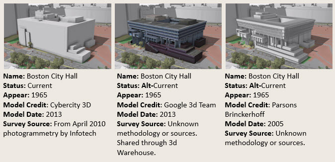
Models of buildings and bridges may represent observations made at different times and at different levels of detail. Each model is worth preserving as a historical document with metadata describing its provenance.
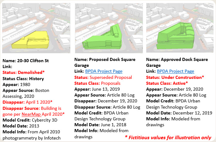
Models produced for design review are also historical artifacts. Including models of ideas that were never built.
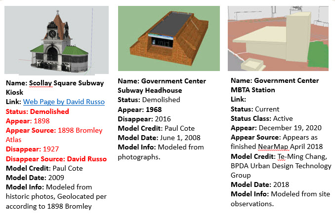
As the model is updated to reflect new conditions, we have a means of preserving and retrieving observations of the past condition. The same schema is also useful for developing and sharing models intended to illustrate historical conditions compiled from multiple sources.
3D models of terrain and buildings are not much different from georeferenced photographs, drawings and maps. It is only a matter of time before tools like the ones referenced above make use of 3D models as part of our cultural memory -- as observations that can be remembered and also as 3D base maps for contextualizing and connecting old photographs and other resources. It is phenomenal how much new information emerges when observations from different points of view and points in time are connected together.
Standard-Based Archival Asset Management Approach
3D models of building shells or terrain tiles are digital documents reflecting observations and ideas, very similar to scanned photographs and drawings. In this sense, the architecture for developing, managing and sharing the city model has many of the functional characteristics of a digital asset management system for geographically and temporally referenced digital documents. When these 3D models become systematically referenced and retrievable, they can be very useful for generating a 3D context for understanding the interrelationships connecting other documents.The citySchema architecture is based on the International Standards Organization Reference Model for Open Archival Information Systems.
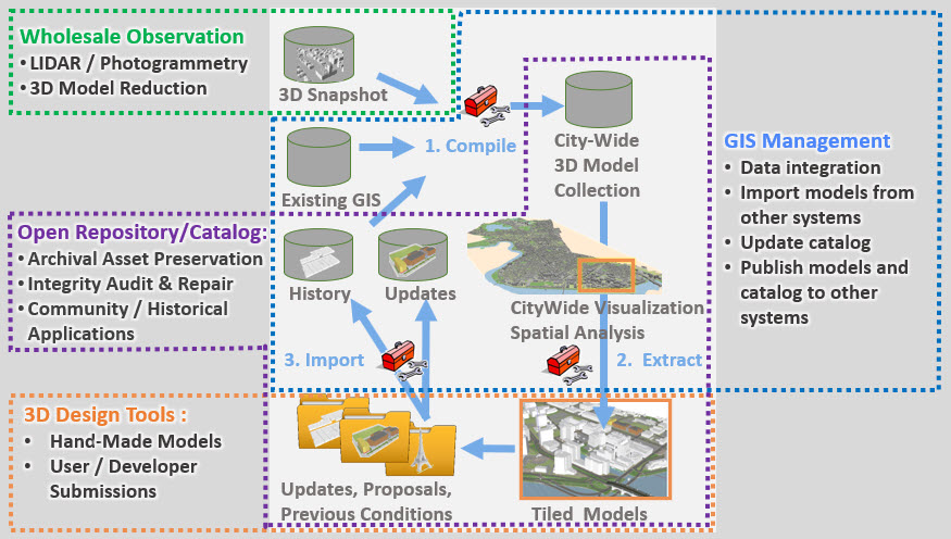
As a bridge between the data-driven, expansive range of GIS, and the deeply hierarchal, but spatially limited world of 3D modeling tools, CitySchema substantially removes the difficulty of exchanging updates -- which can be published and subscribed between independent overlapping city models maintained at architecture firms, campus or municipal agencies, or developers of virtual and augmented reality applications.
Communication between GIS and fully-functioning 3D modeling tools provides non-proprietary pathways for validation, quality control, and migration for an institution's collection of information assets.
How? CitySchema is an Mode of Exchange and a Collection of Tools
The first product of the CitySchema project is our catalog repository for the City of Boston Planning and Development Agency. It is ready to use now by the design and development community. Ready to be harvested by cultural preservation institutions. A working demonstration of the repository schema is published on GitHub to be forked and modified and by other agencies to organize and share their city model resources.
As the project moves forward in the second half of 2021, we wil be publishing the tools that develop and manage the model collections and their catalog. Currently these tools are based on Python, ArcGIS Pro (tasks and geoprocessing tools), Javascript and HTML.
As time moves on, we hope to engage with other interested parties to develop and share tools and workflows for using the metropolitan-scale city models with open-source workflows, including ThreeJS, Blender and Cesium.
Acknolwedgements
This project began at the Harvard Graduate School of Design around 1998 with data from the Massachusetts Geographic Information System. Over the years it has received sponsorship, and collaborative support from the Harvard Center for Design Informatics, the Boston Redevelopment Authority, the City of Cambridge, Town of Brookline, The Open Geospatial Consortium, The Massachusetts Institute of Technology Facilities Department, Harvard University Planning and Real Estate, Sasaki and Associates, Architects and many others.
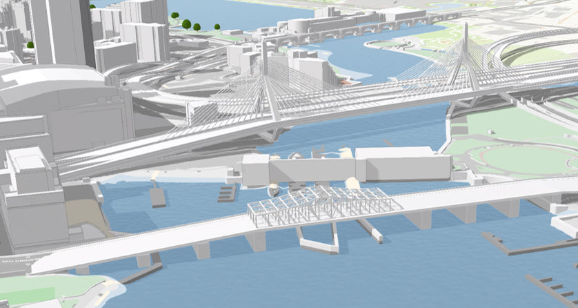
Extending the Boston Metro City Model
Currently, we are finishing several substantial improvements to the architecture for managing and sharing city models sponsored by the Boston Planning and Development Agency. This new architecture will allow us to connect several other projects that wil link several other projects across the Boston metro area.
- Latest Metro3d Slideshow documents the effort sponsored by the BPDA.
- Treatment of 3d Models as historical assets within a collaborative archiving and annotation tool like The Cambridge Digital Architectural Survey and History (another pbcGIS project!)
- Linking of a vast collection of detailed historic maps being compiled by the Norman Leventhal Map Center at the Boston Public Library AtlasScope. We wil be tiling selected historical atlas maps for use in extending the Boston Metro 3D model back in time.
For more information, contact paulbcote at gmail.com.